
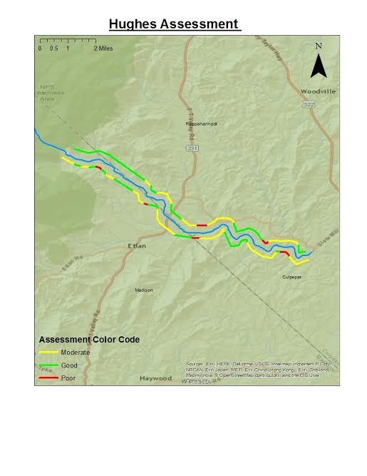
During the summer of 2016, StreamSweepers completed a river ecosystem health assessment of about 12 miles of the Hughes River, starting just below the border of Shenandoah National Park to the confluence with the Hazel River North of Culpeper, VA, near Reva Road. StreamSweepers defines “ecosystem health” as a comprehensive, multiscale, dynamic, hierarchical measure of system resilience, organization, and vigor (Constanza, Robert and Michael Mageau, What is a healthy ecosystem? Aquatic Ecology 33: 105-115, 1999).
Using dual Garmin GPS units, the team conducted assessments using a simple rating system for river bed, bank, riparian forest, and canopy. The screening is a rapid, qualitative assessment of river condition based on a USDA Stream Assessment Protocol. Scores ranging from 0-21 were then grouped into 3 categories; Good health(green), Moderate health (yellow), or Poor health (red).
River Left (North Side)
The health of the river left side was consistently Good (green). The first couple miles of the Hughes is characterized by dense canopy cover and vegetative buffers, stable substrate consisting of cobbles, boulders, and woody material, as well as stable low banks, all of which help to preserve the river’s water quality and health. There are some smaller stretches of the left that exhibited Moderate (yellow) river quality prior to the Hughes flowing under Route 231. This reduced scoring was attributed to low canopy cover, lack of a vegetation buffer, and bank erosion. Below Route 231 the quality was ranked primarily as Moderate because of areas of bank erosion and steep banks. There are a couple of smalls sections below 231 marked as Poor (red) mostly due to steeply eroded banks, lack of canopy cover and buffers and reduced bed composition consisting of silt and sand. The sections marked Good below 231 exhibit a cobbled boulder river bed, gently sloping vegetated banks, buffers of significant depth (more than 30 feet) and consistent tree canopy.
The reduced scoring is due to the proximity of roadways and agricultural fields or mowed yards along the river and the lack of canopy cover as a result. The small or non-existent buffers along the river’s edge resulted in a lower score because erosion, bank geometry, and bank cover were negatively impacted in addition to canopy and buffer. The lack of buffers increases erosion which creates steeper banks and a silty substrate as buffers naturally slow the rate of water flow.
River Right (South Side)
The condition of the river right side of the Hughes River, in comparison to the left bank is much more variable and inconsistent. The two moderate sections seen at the beginning of the assessment on river right were the result of eroded, unstable banks, as well as a lack of bank cover. The next section rated as Poor is a result of a lack of canopy cover and vegetation buffer, as well as the presence of bank erosion. There is a Moderate area then followed by a half mile area rated as Good due to improvements in canopy cover and vegetation buffer, as well as a lack of bank erosion coupled with favorable bank geometry. Overall, river right would be classified as a Moderate score.
This score is mainly a result of the proximity of Nethers Road which follows the river at the Park boundary to Route 231. The presence of bridges and power lines along the road create gaps in the canopy where there is little to no vegetation present. The road also interferes with the natural meandering process of the river. The poor bank geometry, bank erosion, and in some areas unfavorable bank height are a direct result of the road being only five or so feet from the river bank or river itself in many areas. Reinforcement of the banks with big boulders to mitigate erosion has occurred along the right bank. The numerous pull offs present along the road have created gaps in canopy where invasive plants have infiltrated what little is left of a buffer. The other reason for a lower score on river right is the agricultural use on the right side which has reduced the buffer and canopy cover.
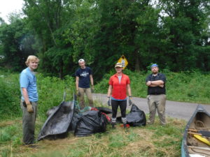
Sweepers removed 15 tires, 4 bags of trash (bottles/cans), two floats, metal detour sign, bike frame, other metal objects, shopping basket, tarp, tent, metal culvert, drywall bucket, grill top, metal Chair, cattle feeder, bottles, cans, hose, table top, green feed bin, one long metal pipe (hammock stand) from the Hughes River in 2016.
This work was supported by many landowners along the Hughes River, some of whom granted financial support within days of our initial request. Others offered their homes as meeting places to allow us to describe our work to the community and build human capital. Many landowners honored our request for access to the river from their property, offered additional contacts and some just joined us along the way to meet our Sweepers and provide moral encouragement. We are grateful for all of you who assisted us in completing this work.
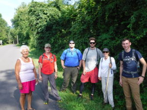
Also pictured is Nethers Rd. Resident, Mrs Lillard (left).